1. (Utah) Lake Powell water level at a historic low. From “TownLife”, Bullfrog Utah, May 28, 2021. For now, the water level continues to drop a little more than an inch a day.
2. (Nevada) Projections for Lake Mead show it dropping well below the lowest level on record, in the next 20 months. NewsNow Las Vegas, April 30, 2021
3. California faces another drought as lake beds turn to dust – a photo essay. The Guardian newspaper, UK, May 30
= = = = = = = = =
COMMENT BEFORE THE CONTENTS
As we have addressed in the past: with the falling water levels comes the loss of the hydro-electric capacity of the dams, along with everything else.
The two reservoirs I’ve used as a thermometer over the years:
Hoover Dam’s Lake Meadnear Las Vegas (Colorado River). It used to be the largest man-made reservoir in the U.S.
I was wondering how they’re doing with the intake water pipe for Las Vegas.
It had a shrinking two feet to go before it would be above water, last I remember. Then came the intention of Vegas Water Officials to unilaterally appropriate water from agricultural lands to their north. The rural people went ballistic; I believe that ended that plan and the hubris behind it!
ANSWER TO THE WATER INTAKE PIPE IN LAKE MEAD: Scroll down to 2. April 2021, from Las Vegas. The concluding lines:
An $817 million project (completed in 2015) to construct a “third straw” to draw water from Lake Mead at the 860-foot level provides security. Two other “straws” take water at the 1,000-foot and 1,050-foot levels.
The last time Lake Mead reached full capacity was in 1983.
2. Glen Canyon Dam’s Lake Powell (also on the Colorado River). Second largest man-made water reservoir in the U.S.
= = = = = = = = =
THE WARNINGS TO CANADIANS
The Americans take what they want. There are quislings in Canada only too happy to collaborate.
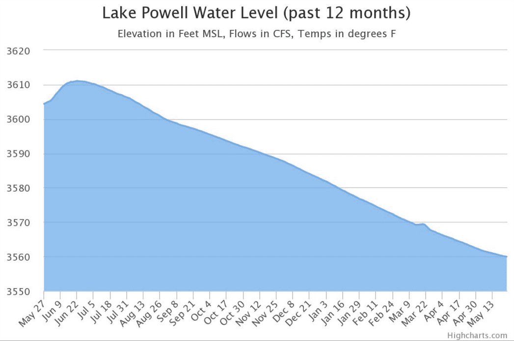
Lake Powell on May 25, as seen from Bullfrog, Utah. Photo: Parker Malatesta
BULLFROG, Utah. — As of May 25, Lake Powell is 43.9 feet lower from a year ago. At 3559.89 feet, the lake is down 140.08 feet from full pool. The man-made reservoir is only receiving 39.4% of its average water inflow so far this year.
“It was so depressing,” said Tim of Glenwood Springs, Colorado, describing his last trip in Bullfrog. He has been coming to Glen Canyon since 1979.
Recent projections from the Bureau of Reclamation are pushing the Upper Colorado River Commission to develop a drought response plan. The commission is made up of officials from Utah, Colorado, Wyoming, New Mexico, and the federal government. The minimum probable projection for mid-2023 shows the water level reaching close to below the minimum power pool level of 3,490 feet. That is the minimum water level needed for Glen Canyon Dam to produce power generation.
A drought plan drafted in 2019 calls for water releases to Lake Powell if it falls below a critical threshold of 3,525 feet. The most probable estimate from the Bureau of Reclamation Water Operations (BOR) report shows it falling below that level as early as March next year. Reservoirs that would be called upon to fill Powell include Flaming Gorge, Blue Mesa, and Navajo.
“It was really a toilet bowl tank for Mead,” Tim said, referring to the creation of Powell. Lake Mead is dealing with its own issues at the moment, with current projections from BOR forecasting the Arizona reservoir hitting a Tier 2 water shortage in 2023.
The flow of the Colorado River, which feeds Lake Powell and Mead, is operated under a vast series of laws and regulations known widely as “the Law of the River.” The most important statute is the Colorado River Compact, which was signed nearly a century ago in 1922. We now know because of various tree ring studies that the estimates used to craft the compact were far too optimistic, the early 20th century saw some of the wettest years since the 1400s.
The legal right to use more than every gallon of the river is claimed by someone. Theoretical rights are known to lawyers as “paper water.” The drought in the western U.S. has contributed to a large disparity between these rights and the actual flow of the river. Since the early 1900s, water demand in the Colorado River basin has increased while water supply has decreased. Per the U.S. Drought Monitor, the majority of Utah is currently experiencing either an exceptional or extreme drought.
Statistics according to lakepowell.water-data.com. Courtesy of HighCharts.com
Don and Mary, a couple from Heber City, Utah, have come to Lake Powell since it was being filled in 1969. “It’s the lowest we’ve ever seen it,” Mary said. They recommend all boaters use either a depth finder or spotter, given that the water is consistently decreasing.
They don’t agree with the idea of the pipeline to Washington County. The Lake Powell pipeline project includes a 140-mile tap from Page, Arizona to the fast-growing St. George area.
“We devote way too much water to agriculture in Utah,” said Don. The couple was split on what should be done with Lake Powell. Don feels there should be a calculated median among all the southwestern reservoirs that states can compromise on. Mary leaned towards the argument of emptying the lake into Mead.
For now, the water level continues to drop a little more than an inch a day.
A Bullfrog resident, who wished to remain anonymous, said on the issue of the water levels, “Mother Nature always wins.”
In this July 28, 2014, file photo, lightning strikes over Lake Mead near Hoover Dam that impounds Colorado River water at the Lake Mead National Recreation Area in Arizona. (AP Photo/John Locher, File)
LAS VEGAS (KLAS) — Projections for Lake Mead show it dropping well below the lowest level on record in the next 20 months.
Bureau of Reclamation projections contained in a 24-month study indicate the lake could fall another 30 feet by November 2022.
Lake Mead is currently at 1,079.46 feet.
The agency monitors the lake level and makes decisions on how to allocate river water. Measurements and projections that are released in August will determine if a Level 1 shortage would be declared. That would trigger automatic cuts in water allocations.
Lake Mead is expected to drop to 1,071.57 feet in June, which would break the record of 1,071.6 feet, set in June of 1981. That’s about four feet below the level that would trigger a federal declaration of a water shortage.
The Southern Nevada Water Authority (SNWA) has been proactive as the current 22-year drought has persisted, and the state has not been using its full allocation of river water as conservation saved water even as the valley continues to grow.
Officials say even if a shortage were declared, the water supply is still sufficient for now. SNWA says it has an eight-year supply of water saved.
If projections hold, that 1981 record could become a distant memory. The 24-month study shows Lake Mead at 1,049.4 feet in November of 2022.
An $817 million project (completed in 2015) to construct a “third straw” to draw water from Lake Mead at the 860-foot level provides security. Two other “straws” take water at the 1,000-foot and 1,050-foot levels.
3. California faces another drought as lake beds turn to dust – a photo essay
Note: Copy and paste the heading into a search engine. Fast and easy. The photos are important, but they won’t upload here.
This is a copy of the text only.
Water shortages and dry conditions are already affecting the state as the governor has declared an emergency in 41 of 58 counties
Verdant hillsides losing their hue, receding reservoirs with bathtub rings of newly exposed earth, crops withering in the fields.
These are the visions of California’s parched landscape as the state braces for another potentially devastating drought. Water shortages and exceptionally dry conditions are already beginning to hit home.
The San Gabriel reservoir lake bed is reduced to mud. Photographer: David McNew/Getty Images
The state is facing yet another hot, dry summer ahead, and the governor has declared a drought emergency in 41 of the state’s 58 counties. More than 37 million Californians reside in these drought areas, according to the US drought monitor.
“This is without precedent,” Newsom said at a news conference announcing the first two declarations in April, speaking from the bed of Lake Mendocino that had been reduced to arid, cracked clay. Not long ago, he would have been standing under 40ft of water. “Oftentimes we overstate the word historic, but this is indeed an historic moment.”
Governor Gavin Newsom holds a news conference in the parched basin of Lake Mendocino in Ukiah. Photographer: Kent Porter/Associated Press
A child walks across the parched bottom of Lake Mendocino. Photographer: Justin Sullivan/Getty Images
Many of the state’s reservoirs are at extremely low capacity and levels are expected to drop further in the coming months. Already, the state’s 154 major reservoirs are collectively at 71% of where they typically are on average. Federal climate analysts with the National Integrated Drought Information
System called the outlook for California’s reservoir levels recovery “grim” in their most recent report.
Water levels at Lake Oroville have dropped to 39% of capacity. Photographer: Justin Sullivan/Getty Images
Houseboats in Lake Oroville are dwarfed by the exposed banks. Photographer: Justin Sullivan/Getty Images
These conditions only began to develop in May of last year, according to federal monitoring systems. But now into a second consecutive dry year – characterized by a hot summer and little rainfall to replenish the dehydrated landscape through the winter months – by mid-May this year 93% of the south-west and California was in drought, with 38% of the region classified at the highest level.
“It really stands out how rapidly this drought has developed and intensified,” said Brian Fuchs, a climatologist, during a webinar this week hosted by the NIDIC.
Northern California’s reservoirs, which heavily depend on the rapidly disappearing mountain snowmelt, have been among the hardest hit. Lake Shasta and Lake Oroville, two of the largest, have fallen to 44% and 39% of their total capacity respectively. Inflow into Lake Shasta is even lower than it was in 2014.
Many farmers are preparing for an expected water shortage by removing water-dependent crops, such as almond trees like these in Snelling. Photographer: Justin Sullivan/Getty Images
A sign in Buttonwillow, Kern county. Photographer: Frederic J Brown/AFP/Getty Images
To prepare for declining reserves, the California Department of Water Resources reduced farmers and growers to 5% of their expected water allocation in March. The move sparked an outcry from California’s agricultural belt, which is likely to be hit hard by the drought.
During the last drought, between 2014 and 2016, the agriculture industry lost roughly $3.8bn, and more than half a million acres couldn’t produce for lack of water. Farmers and ranchers have already begun to cull crops, fallow fields, and thin their herds in preparation.
Officials have also had to step in to help salmon raised in the state’s central valley region reach the Pacific Ocean, as waterways grow too shallow and warm for them to safely make the journey. Tens of millions of young fish will instead be trucked out to sites across the coast.
With rivers like the American River growing too warm and shallow for fish to reach the ocean, juvenile Chinook salmon will be transported by truck. Photographer: Nina Riggio/Reuters
Boat docks sit on dry land at Folsom Lake in El Dorado Hills. Photographer: Justin Sullivan/Getty Images
Drought has always played a part in California’s climate, and it’s not unusual for the region to see periods of dry years interspersed with wetter ones. But, rising temperatures are fueling deeper extremes and climate scientists believe the cycle will only intensify.
With only a short two-year reprieve since the state was declared drought-free – after the period between 2012 and 2015 became the driest four-year period recorded – the negative impact that dry conditions had across the state are still fresh in residents’ minds.
A park visitor runs on the dry Folsom Lake bottom in Granite Bay. Photographer: Justin Sullivan/Getty Images
A resident fills a water tank with recycled water from a fill station in Oakley.
In an attempt to mitigate some of the expected impacts, Newsom has earmarked $5.1bn over four years for water infrastructure and drought response. The state is also hoping to apply key lessons learned through the last drought period, including establishing new standards of use for water, increasing efficiency requirements, and assessing and intervening when water systems fail. Still, as conditions worsen, the state will continue to call on residents to adapt.
“It’s time for Californians to pull together once again to save water,” said California Natural Resources Agency Secretary Wade Crowfoot in a statement issued with the emergency declaration. Encouraging shorter showers and limiting wasted water during every-day activities like dishwashing and teeth brushing, he added, “all of us need to find every opportunity to save water where we can”.
Marin county became the first county to impose mandatory water-use restrictions on 1 May. Photographer: Justin Sullivan/Getty Images


 A Flourish chart